SOUTHWEST PAPUA | INDONESIA
THE EMERALD KARST OF THE EQUATOR
Zamrud Karst Khatulistiwa
RAJA AMPAT GEOPARK
The Emerald Karst of The Equator
Raja Ampat Geopark is a special area, in the form of a karst archipelago that lies right on the equator. Its geological uniqueness is on an international scale, with the discovery of the oldest exposed rock in the world, aged 439 – 360 million years ago (Silur – Devonian) located in Misool.
Like a book, the geological history of Raja Ampat area is completely composed and represents almost a tenth of the age of the earth.
This area cannot be separated from the megabiodiversity of Papua. So it is not surprising that most of the area is included in the conservation area. Raja Ampat marine and terrestrial ecosystems are home to hundreds of unique, rare, and endangered species. It is also home to various types of endemic animals and plants, which cannot be found anywhere on Earth.
Various indigenous people and immigrants, blend into the local community and contribute to the cultural diversity of Raja Ampat. They inherit a priceless cultural wealth, both in the form of objects and intangible objects. Everything is perfectly recorded, such as in the form of rock paintings from prehistoric times, sacred egg stones from the folklore of the Origin of Raja Ampat, to traditional dances and ceremonies, which illustrate the close relationship of the local community with the natural surroundings.
Like the pages of a book Raja Ampat records the history of the Earth.
Through its unique geology, marine and terrestrial mega biodiversity, and cultural diversity, we present The Emerald of Equator, Raja Ampat Geopark.
The geological heritage on Misool Island has become a part of life from the past to the present, and can be witnessed directly by anyone as one of the tourist attractions for Raja Ampat.
About UNESCO Global Geopark
RAJA AMPAT GEOPARK BOUNDARIES
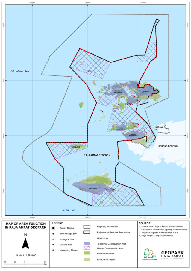
Most of the Geopark area is located in the central part of the Raja Ampat Regency, Southwest Papua Province. However, not all administrative areas are the boundaries of the Raja Ampat Geopark.
2.713
ISLANDS
As a water boundary, the Raja Ampat Geopark uses a Regional Marine Conservation Area and a National Marine Sanctuary.
5
KKPD
2
SAP
On land, the Raja Ampat Geopark is bordered by the district administration area and nature reserves.
8
NATURE RESERVE
STAY TUNED TO OUR SOCIAL MEDIA
LATEST NEWS

Continue reading "REGINA LAPON, SUPERWOMAN DARI KABARE, PENJAGA SATWA ENDEMIK WAIGEO UTARA"
Subscribe our official Youtube Chanel:
Raja Ampat Geopark @rajaampatgeopark
or simply just click the button >>>
We are here if you have a question.
We are happy to open ourselves to share information about the features of Raja Ampat for you. Just write it on!
©2022 Raja Ampat Geopark Management Body.
All Rights Reserved.


