
-
 5542 Hits
-
 81.84% Score
-
 14 Votes
|
|
Trailhead |
|---|---|
|
|
46.32750°N / 14.58944°E |
|
|
Spring, Summer, Fall, Winter |
|
|
1968 ft / 600 m |
Overview
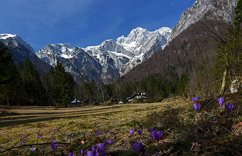
Kamniška Bistrica is a beautiful, deep valley reaching from the south into the group of Kamnik and Savinja Alps. Close to the valley-end there's a nice karstic source of Bistrica river, that's also the place where a broad asphalt road ends. The place is very popular with tourists who come there for short hikes and to visit several natural beauties.
The valley is also the most important trailhead for the tours of hikers, climbers, mountaineers and tour skiers. We shall describe only the trailheads near the valley end, there are many more in the outer areas of the valley. Close to the valley end is also the lower station of Velika planina cable way, operating throughout the whole year.
Geography
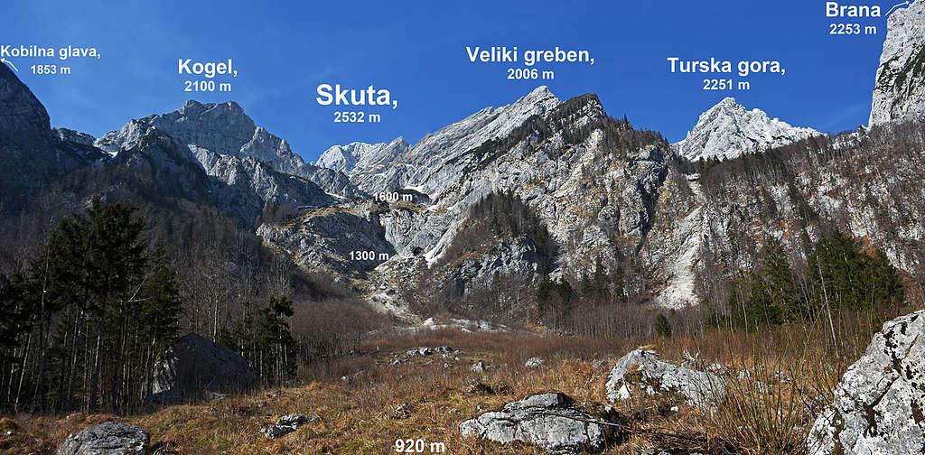
Some of the features of the valley are seen on the interactive map below. Around the valley almost all the highest summits of Kamnik & Savinja Alps are arranged. West of the valley-end there's the group of Kalški greben and Krvavec. The southern summits of this group are more often reached from the other side, the northern ones sometimes also from our valley. On the northern side of the valley the crest with the highest summits is stretching - from Grintovec, 2558 m, on the west, to Ojstrica, 2350 m, on the east. These summits are of course also being ascended from the other side. On the eastern side of our valley, a few ridges are deterring from the main ridge and coming down to Bistrica river. In these ridges are some interesting summits, further towards the east there are also some broader plateaus. And towards the south, the valley is opened towards Gorenjska (Upper Carniolia) plane. In the valley mouth there's the medieval Kamnik town, further to the south there's Ljubljana, the capital of Slovenia.
All the mountains around Kamniška Bistrica are described on separate SummitPost pages, many sub-pages are describing also the route on those mountains and connection routes. See the Kamnik and Savinja Area page!
Getting There
The valley-end of Kamniška Bistrica can be quickly and comfortably reached from the south by car - via the Kamnik town. Along this road also a regular bus connection is operating. Many visitors are reaching the valley-end also by bikes. The hills are not steep and the popular hut there is on the altitude of only 600 m. As mentioned on the area page, the Ljubljana airport is very near, some 10 km away from Kamnik town.
Hiking trailheads
Kamniška Bela parking place
Coming up by the valley, it's on the right side of the main road, near the confluence of Bela creek and Kamniška Bistrica river. Nearby is on the creek a small waterfal, a more beautiful one (Orglice) is deeper in the side valley. Through the valley of Bela a good, but steep path goes on the Presedljaj saddle, from there, you can continue either to the right on Konj, Rzenik and further to Velika planina, or to the left on Korošica meadow. The hut on Korošica was burnt a few years ago, there are plans to rebuild it. From Korošica meadow you can climb: Ojstrica, Lučka Baba, Planjava, Kamniški Dedec, Vežica and other summits.
Predaselj parking place
It's used only for short valley hikes, mostly into the gorge of Predaselj and along the river.
Kamniška Bistrica hut parking place
There the main road ends and continuation with private car is usually prohibited. From the hut we go to all other destinations, but we shall describe them in separate chapters. Just at the hut the popular route on Kamniško sedlo (saddle) starts. From there, the summits of Brana and Planjava are the nearest goals. Already below the saddle, V Klinu, the route towards the NE deters. By a wild valley we can scramble to Srebrno sedlo (saddle) and further to Planjava, or we can do a more serious climbing route over Zeleniške špice (Staničev vrh) ridge. Kamniški Dedec is a lower destination summit too.
Kurja dolina
It's the western side valley of Kamniška Bistrica. A completely pathless terrain, but its north oriented slopes allow a few quite difficult scrambles towards the summits: Vrh Korena, Kompotela and Mokrica.
Žagana peč trailhead
It's close to the macadam road end in the valley-end. There a weak, unmarked hunters trail deters eastwards. Above, it gets lost on the Kalce plateau, but from there we can without bigger difficulties reach the summit of Kalški greben.
Kokrsko sedlo material cable way station
On this parking place the good and popular marked path on Kokrsko sedlo deters (towards the NW). High above the saddle (and its hut) there's Grintovec, the highest summit of Kamnik and Savinja Alps. We can reach from the saddle also other high summits in the main crest, and on the other side Kalški greben.
V Koncu
That's the real end of the valley. There are trailheads for the following two routes:
1. By Gamsov Skret. Towards the north a very steep (short climbing passages), weak trail goes on the high plateau above, and further on the summits: Kogel, Štruca, Dolgi Hrbet, Skuta.
2. By Žmavčarje valley. This passage goes in the N-NE direction. By a weak, unmarked trail we can reach the Bivak pod Skuto and further by marked paths and ferratas many summits around the plateau of Mali podi: Skuta, Rinke (3 summits), Turska gora and Brana further to the east.
The big round tour
The big, multy-day round tour from Kamniška Bistrica would be the following:
Day 1: Kamniška Bistrica - hunters path - Kalški greben - Kokrsko sedlo.
Day 2: Kokrsko sedlo - Grintovec - Dolgi Hrbet - Skuta - Bivak pod Skuto.
Day 3: Bivak pod Skuto - Rinke - Turska gora - Brana - Kamniško sedlo.
Day 4: Kamniško sedlo - Planjava - Ojstrica - Kamniška Bistrica.
To a hiker Kamnik & Savinja Alps can hardly offer more, equivalent are perhaps the big routes, starting in the northern trailheads (Jezersko, Logarska dolina, etc.).
The landmarks of Kamniška Bistrica
While the summits and routes around the valley are well described on SummitPost, one would perhaps be also interested in visiting a few natural landmarks of the valley. Find them on the above map!
Orglice Waterfall
It's in the valley of Bela creek, 1 h of walk from the parking place. Lonesome place, nice especially when the creek has enough water.
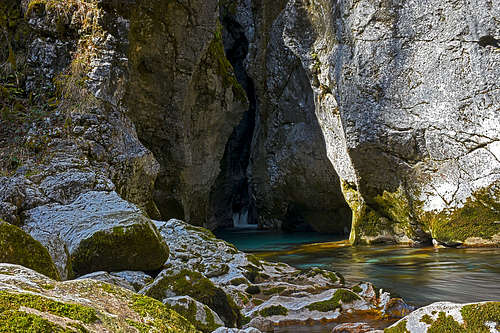
Predaselj gorges
The Bistrica river cut up to 35 m deep, on places only a meter or two wide gorges, which a good tourist path visits. The place down by the river is very picturesque and certainly worth of that 30 min hike.
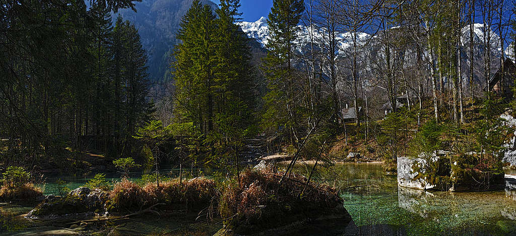
The source of Kamniška Bistrica
This is a small lake of crystal clean water, a karstic source of Vaucluse type. It can be encircled by a weak trail. Some 200 m down the valley, there's also a small side source, called Izvirek (A Little Source). Marked path goes also along it.
|
|
Žagana peč
In the valley there are many big limestone boulders which came down the steep mountain slopes thousands of years ago. Some of them are named, but the most known is Žagana peč. It has a crack, so it looks like if giants were trying to cut or saw it. The valley-end is revealing on many places also remains of glaciation (in the last ice age).
Rokovnjaške luknje
Near the trail to Kamniško sedlo there are caves in conglomerate in which hundreds of years ago many outlaws lived. In those times the valley-end was a very remote place, safe for legendary outlaws (escaping many years long service in the Habsburg army).
When to visit Kamniška Bistrica?
The valley itself can be visited all the year and also the road to the hut is mostly cleaned. See the detailed mountain and route descriptions to learn which tours can be done also outside the summer season!